
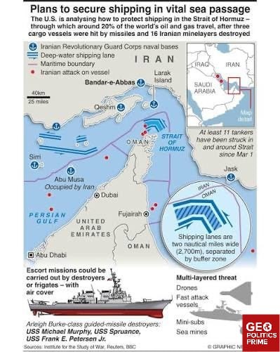
...les) wide, separated by a 2-nm buffer zoneThis Traffic Separation Scheme is so narrow that vessels become sitting ducks — potential targets for Iran's arsenal that includes: swarms of Iranian Shahed-style drones IRGC fast-attack boats armed with anti-ship missiles explosive-laden kamikaze #drone boats designed for naval warfare Ghadir-class midget submarines specifically built for the shallow Gulf waters thousands of covertly-laid naval mines that can be laid covertlyThese weapons are deva...
...statingly cost-effective compared to the billions of dollars invested in a US carrier strike group.If #Trump were to start a ground invasion, Iran's geography transforms it into a natural fortress, shielded by the Zagros and Elburz mountain ranges.These rugged terrains would strip invading forces of the speed and surprise that modern militaries rely on.Iran's coordinated retaliatory strikes pummeling US military infrastructure across the Middle East, strikes on Gulf oil infrastructure, and...
... the persistent disruption of Strait of Hormuz shipping are stretching US resources.Any land operation would potentially snowball into a military quagmire all but certain to ignite US domestic fallout over casualties, oil-price shocks, and a new entanglement in the Middle East.US-Israel-Iran war |

...n has backfired, while Iran has pivoted to its greatest strength: a low-cost, high-impact asymmetric retaliation.Iran has turned the Strait of Hormuz into a high-stakes chokepoint where geography and strategy strongly favor the defender.Lodged between Iran to its north and the UAE and Oman to its south, the Strait of Hormuz is around 160km long and narrows to approximately 39 km (21 nautical miles) at its narrowestThe shipping lanes in each direction are approximately 3.7 km (2 nautical mi...